 SYDNEY’S NORTHERN BEACHES – 20-21 July 2024
Well, this is Part 3 for me but probably Part 5 or 6 for John G. John has made it his goal in life to identify all the sea caves up and down the NSW coastline. He has a book written by John Dunkley which was produced prior to the GPS and he’s trying to locate the caves in the book, GPS them, and document them. So, I rocked up on Saturday to be part of the adventure.
The weather gods certainly looked down upon John, stunning blue skies AND a NW wind (predicted to be 50k/h) which flattened out the swell, so for the places where the sea could prevent us exploring, there was no question about that on Saturday. Our first target was the northern end of Queenscliff Beach to do the Wormhole, WL45 and WL110 (that’s probably a tag at each end of the tunnel.

Also known as the Queenscliff Tunnel, the tunnel is easy to get to, you just walk to the northern part of the beach, pass the ocean swimming pool and up onto the rock shelf and voila, there it is.

A man named Robert Lewers of Freshwater employed a Mr D. Bevan, to excavate the tunnel which was finished by January 1909. Apparently, he almost built it single handed. This photo is the entrance to the 25m tunnel.

And this is the exit at the other end.
Our next stop was Collins Flat Beach to find the Collins Beach South Cave, W129, ollins Beach North Cave, WL127 and Cave #2, WL128. The descriptions in the Dunkley book were a little sketchy!

This looked like what was described for The Collins Beach South Cave, notably some steps at one end of the cave (which are middle right in the photo.

John pouring over the book to see if this cave is Cave #2.

The book notes this waterfall, and it also notes that there were some possible Aboriginal habitation caves, and if so, this would have been a wonderful source of water.

There were steps up to the waterfall so I popped up there to see what the view was like.

Finally we found said habitation cave, WL127, and it’s really big, 40m from end to end, mind you it’s on the wrong side of the beach according to the book.

On the walk out (on the tourist track), we came across five Brush Turkeys, they aren’t actually social birds, so we were surprised to see a group of five.
So, we’re back in our cars (big thanks to Marcia for driving Trish and me back and forth), and heading for St Michaels Cave, WL19, which is in the Bangalley Head area. We had lunch (trying to find a sheltered spot) up at the top of the dodgy downclimb to the rock shelf.

This is the dodgy route down.

Initially, we were negotiating over a lot of rocks/boulders, I was thinking that the 500m that we had to walk would take forever.

At this point I’m wondering why we aren’t down on the lovely flat rock platform.

Finally on the rock platform.

The entrance to the cave was easy to find. It is “gated” but the gate has a few slats missing so anyone can walk in. As we did, here’s Kathy making her way to the back with Ellie beside her.

You can just see Kathy in the pic, tells you how big the cave is and it still goes, a small offshoot behind Kathy extending roughly another 20m.

Looking up into the extension.

Some cave formations on the side of the cave.

It’s obvious that locals treat this cave as “the place to party”, I suggested that we pick up garbage, I had a small plastic bag, but I think Al had this big bag, and we filled it with trash, and still there was more to remove, if we come back again we’ll bring bigger bags. One of the guys were carrying it out, and when we got to the rock platform (as we were going to go further), I asked a random guy if he would carry it up to the top and surprisingly he said yes! I brought it home to put in my garbage.

Back on the platform, we walked around to the next bluff, Al, Onni and John went around the bluff but it was a lot more rock hopping, I was happy to stop at the end of the platform.
We were back at the top of the cliff-line at around 4.30pm and that was the end of our exploration, was a great day and we achieved all of John’s goals (other than finding a reported cave at the northern end of the platform – not found). I decided that I didn’t want to camp (in the cold), so headed back home to my electric blanket, setting my alarm so I could drive back to Narrabeen on Sunday morning.

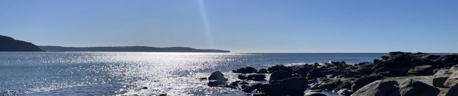
Sunday morning and what a stunning day! And, it looked like the calm seas were in our favour again.

Our first cave was Palm Beach Cave (WL3), surprisingly at Palm Beach. The walk was super easy, after walking past the ocean swimming pool, we encountered lovely big flat platforms to walk on, then we came to a possible “wet feet area”.

Was a bit of a drop to negotiate down but Onni was there to give anyone who needed it a hand.

Connor negotiating across, making sure to get far enough across between the swell of the ocean (when you’d get wet).

Onni took the high road, but it looked dodgy to me.

A bit of bouldering before we found the cave at the cliff-line.

A little camouflage but the entrance was hard to miss.

About where you can see the people, there is a small hole/squeeze.

I was the first to go down (feet first), and then negotiated along the squeeze/crawl until I got to a spot where (a) I had to take my helmet off and (b) I was having to negotiate on my side, after going about 15m I decided that I just couldn’t go any further, so reversed back. Onni and Ellie then went through, I thought if my chest was too wide that Onni wouldn’t make it, but he did. So, Onni and Ellie traversed the 25m of crawl/squeeze and saw the big chamber at the end. I’m a bit envious.

Ellie making her way out with Connor giving instructions.

Me coming out of the entry hole to get to the squeeze. I had so much sand in my hair from taking my helmet off and crawling through the cave, had to wash my hair twice to get the sand out!(photo: Marcia)
We explored a little further around the cliff-line but couldn’t find anything, the walking was dead easy though.
We then headed to Whale Beach and probably found a couple of the Whale Beach Caves 1 – 4 but we haven’t worked out which number is which. We almost got to Platform Cave WL15 and The Ovens WL16.

The sea is still looking calm, and the rock platforms were amazing, such easy walking.

Even when it wasn’t flat it was easy.

We found a canyon like rift which Onni explored, didn’t go anywhere and wasn’t written up in the Dunkley book, so not a “cave”.

Stunning platforms, note the flat sea and no waves – a different story to an hour later.

We’re about 20m from the cave now, and there’s this rift in the rock that was pretty impressive, you just had to time yourself to cross without getting wet.

And then the swell picked up a bit, not sure whether it was just here, maybe the rocks on the ocean floor near the cave were what was making the waves bigger. The cave is where the white water is.

We all had to climb up to the ledge to get around to the cave.

We congregated at the end of the ledge and there was another one below that which you could walk up to get into the cave. It looked decidedly dodgy to me, particularly when sometimes the waves came up as high as the ledge Onni is standing on, so I reversed out and Rod, the 2 kids, Kathy and Marcia followed me onto a safer area.

So, now John and Onni have been into the cave and are exploring further along the headland.

And that’s when the waves started to get bigger – almost out of the blue. John’s not getting wet, but Onni was around the corner and was drenched.

This was probably the biggest wave, and it was a bit scary, you can just see Onni’s white helmet around the corner right of John. After this they made their way back to the cave but were in there for ages as the waves are creating havoc, it was such a relief to see them make their way out.
Next, we headed to Warriewood Beach where we walked down a fishermen’s track to get to the rocks, and then drop down to the next level to poke our heads into South Warriewood 1 Cave, WL40.

This is a cave that can only be entered if you swim in, you could poke your nose around the edge to see into the cave but it was too exposed for me standing on that ledge, so I saw nothing LOL.
From there we went back to the beach and walked to the northern end where there is a cave right on the beach, Weathered Dyke Cave WL39.

You crawl in about 20m to this part, and then it’s a crawl, I’d had enough crawling in sand the day before, so I let Onni go by himself.

He crawled in for about 20m or so and then it opened up enough to stand up, then it went for another 10m but nothing significant and no reason for me to crawl through sand to see nothing LOL.
This was my first MSS trip after a lazy 6 weeks in Bali with no exercise whatsoever, and it was so good to get back in the saddle with a trip that wasn’t physically challenging, plus the bonus of absolutely perfect weather, thanks John & Kathy for putting on the trip.
Still some unfinished business here, have to go back to area between Palm and Whale Beaches I believe, looking forward to some dates being set!